
About
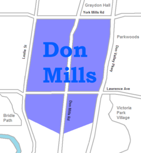
Don Mills is a mixed-use neighbourhood in the North York district of Toronto, Ontario, Canada. In 1998, North York, including the Don Mills community, was amalgamated into Toronto proper. Consisting of residential, commercial and industrial sub-districts. In several ways it became the blueprint for postwar suburban development in Toronto and contemporary residential neighbourhoods. It is bounded by York Mills to the north, Eglinton Ave. to the south, Leslie Street to the west, and the Don Valley Parkway to the east. It is part of federal and provincial electoral district Don Vallet East, and Toronto electoral ward 16: Don Valley East.
History
The Don Mills area was first settled by Europeans in 1817. The area was a considerable distance from the town of York, but the Don River provided an easy means of transportation, and also a source of power for a number of mills along its length.
While the city of Toronto steadily expanded, the Don Mills area remained rural until after the Second World War. It was cut off from the city by ravines to the south, east, and west. Only two roads connected to the area: York Mills Road and Don Mills Road. In 1950 the area consisted of about 20 farms.
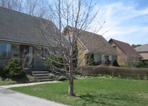
Don Mills was designed as a model community between 1952 and 1965. Land use, architectural design and building materials were carefully regulated. Many aspects of its design have been imitated in suburban developments across Canada. Its planners would give people priority over industry and cars.
This combination of emptiness and proximity to the city attracted the attention of industrialist E.P Taylor. His original plan was to erect a brewery on the site, along with a small community to house the workers. Taylor had limited previous experience in the property development business, but had built a project named the Wrentham Estates in York Mills. Seeing the profit to be made with such projects, Taylor abandoned the brewery idea and decided to simply build a new town on the 2,000 acres (8.1 km2) he had acquired.
In 1951 he began planning the Yorktown community (as it was first known), and it was announced on March 11, 1953. The community was to be built on about 8.35 km2 (3.22 sq mi) of farmland centred at the intersection of Don Mills Road and Lawrence Avenue East, with an expected cost of $200 million. Development was headed by the Taylor-owned Don Mills Development Company, (known as O’Keefe Realty in the days of the brewery development).
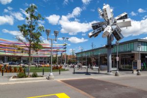
In 2006, Don Mills Centre was demolished to make way for Shops of Don Mills, a large shopping centre. The shopping centre opened in April 2009.
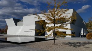
At Wynford Drive and the Don Valley Parkway, a new $300 million cultural project was built on 6.8 hectares (17 acres) of land. The project, whose foundation was laid on May 28, 2010 by Prime Minister Stephen Harper and His Highness the Aga Khan, is designed by award-winning architects: India-based Charles Correa, Japanese architect Fumihiko Maki, Lebanese landscape architect Vladimir Djurovic and the Toronto-based Moriyama & Teshima Architects. The Aga Khan Museum was opened in September 2014.
Demographics
The city places Don Mills in a community called Banbury-Don Mills. In 2006, it had a population of 25,435.
Major ethic and cultural groups in 2001:
- ChineseChinese – 12%
- English – 11%
- Canadian – 11%
- Jewish – 7%
- Scottish – 7%
- Irish – 5%
- East Indian – 4%
- German – 3%
- French – 2%
- Polish – 2%
- Other – 36%
Schools
The Toronto District School Board (TDSB) is a public school board that operates three elementary schools in Don Mills, Greenland Public School, Norman Ingram Public School, and Three Valleys Public School. TDSB also operates one secondary school in the neighbourhood, Don Mills Collegiate Institute. Don Mills branch of the Toronto Public Library is located in the neighbourhood.

Parks
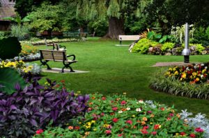
Don Mills is home to a number of municipal parks including Bond Park, which has sports fields and an arena, Chipping Park, and Moccasin Trail Park. The latter two parks are situated near the Don Valley , which forms a part of the Toronto ravine system. Municipal parks in the neighbourhood are managed by the Toronto Parks, Forestry and Recreation Division.
Transportation
Several major roadways are situated in Don Mills, including Lawrence Avenue, and York Mills Road, which serves as the neighbourhood’s northern boundary. To the east, the neighbourhood is bounded by the Don Valley Parkway, a major municipal controlled access highway. Eglinton Avenue is a major roadway situated south of Don Mills.
Public Transportation in Don Mills is provided by the Toronto Transit Commission (TTC). The TTC operates several bus routes in the neighbourhood. The TTC plans for light rail service in the neighbourhood by 2021, with the opening of Line 5 Eglinton, a light rail line to be operated as a part of the Toronto subway system. Stations for the new line would be located along Eglinton Avenue, with Aga Khan Park & Museum and Science Centre station situated in the south of Don Mills. The neighbourhood serves as a transition point for Line 5 Eglinton, with the line operating as a surface level route for every stop east of Science Centre station.